26 April 2003
Source of photos and maps: Mapquest
and Terraserver.
See related:
Eyeballing
the Air Force Satellite Control Network
23rd Space Operations Squadron
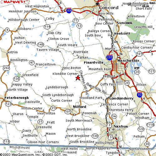
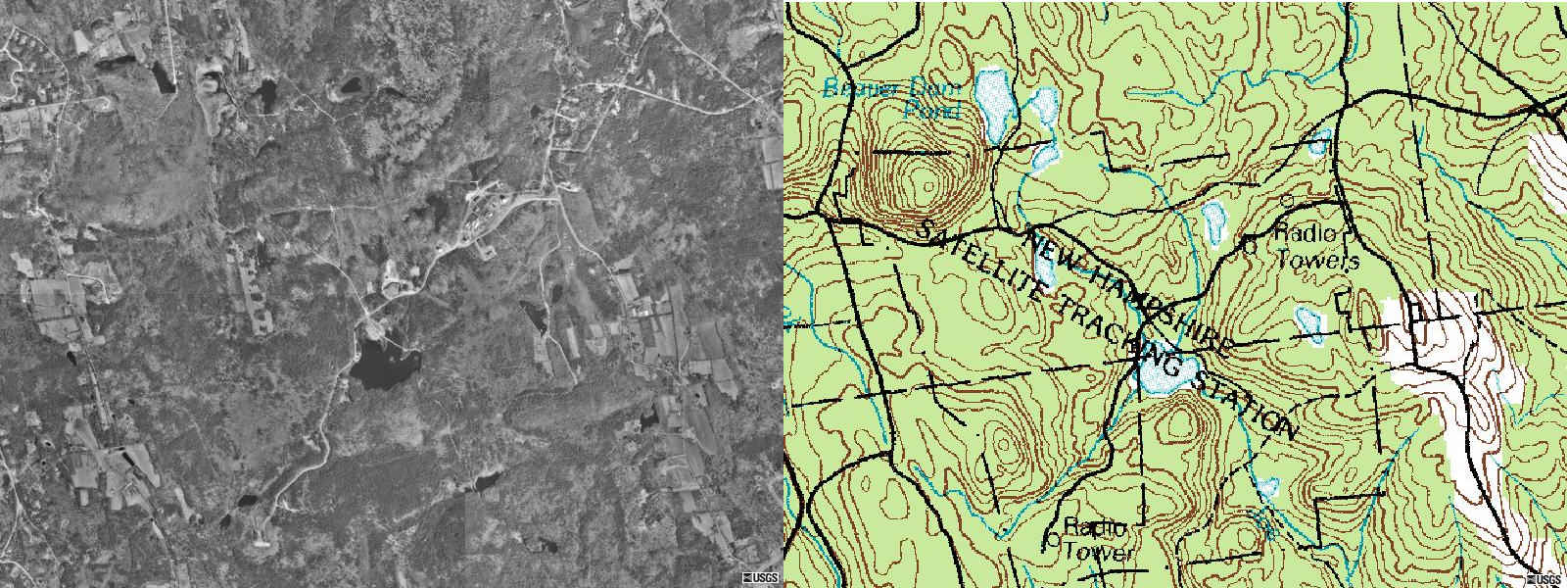
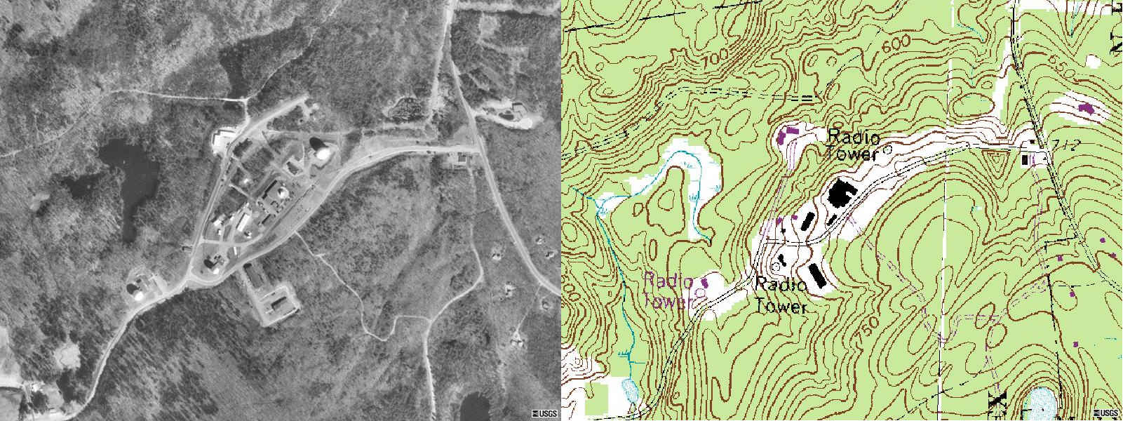
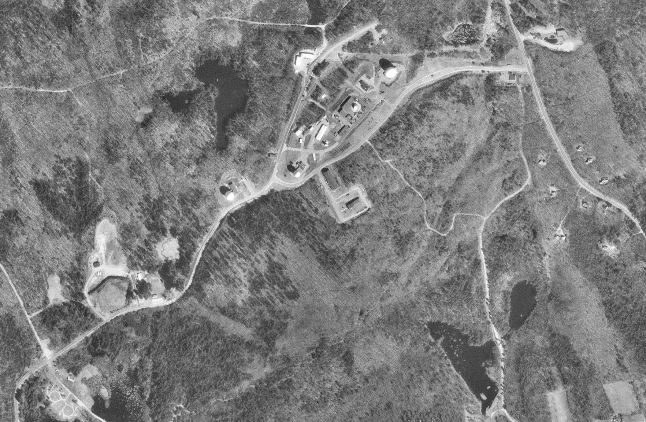
New Boston Air Force Station, N.H.
50th Space Wing
http://www.schriever.af.mil
50th Space Wing, a component of Air Force Space Command, is located at Schriever
Air Force Base, Colo. The wing was originally established on July 8, 1985
as the 2nd Space Wing, and then redesignated the 50th Space Wing on January
30, 1992. The wing manages the worldwide Air Force Satellite Control Network
(AFSCN).
Controls satellite programs including the
Defense Support Program, the
Navstar Global Positioning System, the
Defense Satellite Communications System,
NATO III, and
Milstar.
MISSION
Provide combat capability through command and control (C2) of communication,
navigation, warning, and surveillance satellite weapon systems and conduct
of expeditionary operations.
The mission of the 50th Space Wing is to command and control operational
Department of Defense satellites and manage the worldwide Air Force Satellite
Control Network. The wing operates satellite operation centers at Schriever
AFB, and remote tracking stations and other command and control facilities
around the world. These facilities monitor satellites during launch, put
the satellites in their proper orbits following launch, operate the satellites
while they are in orbit, and fix satellite anomalies when they occur.
The 50th Operations
Group commands and controls assigned operational Department of Defense
satellite systems, trains space operations crews, and provides operational
support and evaluation functions for management of satellite control centers
and assigned ground stations. The group is composed of eight squadrons.
The group is also responsible for the daily operation of the majority of
the
AFSCN.
The network consists of eight subordinate tracking stations located around
the world: 23rd Space Operations Squadron, New Boston Air Force Station,
N.H.; Detachment 1, Vandenberg AFB, Calif.; Detachment 2, Diego Garcia,
Chagos Archipelago; Detachment 3, Thule AB, Greenland; Detachment 4, Kaena
Point, Oahu, Hawaii; Detachment 5, Andersen AFB, Guam; Colorado Tracking
Station, Schriever AFB, and Oakhanger, England, operated by the United Kingdom.
The tracking stations command, track, record and process on-orbit satellite
data in support of DOD, NASA, and NATO programs. The wing assumed operational
control of the AFSCN in October 1987.
http://yosemite.epa.gov/r1/npl_pad.nsf/8b160ae5c647980585256bba0066f907/ab924c4606a3ea4b85256b42006066fe?OpenDocument
The New Boston Air Force Station
(NBAFS) property is located on Chestnut Hill Road in the towns of New Boston,
Bedford, Amherst, and Mt. Vernon, Hillsborough County, New Hampshire. The
2,826-acre property is currently owned by the U.S. Air Force (USAF), and
consists of developed areas, including a Satellite Communications terminal,
antenna systems, engineering, maintenance, security, and administration systems;
and undeveloped areas, including five brooks, 15 ponds, former bombing and
strafing ranges, recreation facilities, a remote boresight tower, wells,
and a pumping station. The property is bordered to the south by the Joe English
Reservation; and to the east, west, and north by undeveloped land, with light
residential construction to the east.
From 1942 to 1958, the NBAFS property was used
as a bombing and strafing target range. Joe English Pond was the primary
target, but much of the remainder of the property is littered with unexploded
ordnance (UXO) and explosive residues. Since 1958, the property has operated
as an Air Force Tracking Station. During the course of routine USAF training,
maintenance, and operating procedures, toxic and hazardous wastes have been
used and disposed of on the property. From 1960 until 1968, solid waste,
including scrap wire, recording tapes, empty 50-gallon cans, and construction
debris, was deposited in a landfill just north of Joe English Pond. From
the mid-1970s until 1989, fluids from the vehicle maintenance building and
wash stall were passed through an oil/water separator prior to being discharged
to the ground outside the building. Analytical results of soil samples collected
from this area in 1989 indicated the presence of chlorinated solvents,
semivolatile organic compounds (SVOCs), and metals including chromium, copper,
zinc, mercury, and lead. Currently, these fluids undergo wastewater treatment
prior to discharge, and floor drains have been sealed. Since 1974, a chemical
spill/drum storage area was used to store hazardous wastes generated by regular
on-site activities. Drums and batteries have all been removed from this area;
however, stained soils were still visible during a site investigation in
1989. U.S. Environmental Protection Agency investigations conducted on the
property to date include a Preliminary Assessment and Site Inspection, completed
in 1993 and 1994, respectively.
Groundwater occurs in overburden at depths ranging
from less than 1 foot (ft) to 8 ft below ground surface; groundwater flow
is toward the on-site brooks and ponds. There are no public drinking water
supply wells located within 4-radial miles of the property. The estimated
population served by private drinking water supply wells within 4-radial
miles of the property is 6,397. The location of the nearest private drinking
water supply well is unknown, but it is estimated to be located between 0.5-
and 1-radial mile from the property. Two on-site NBAFS drinking water supply
wells, previously serving 160 people, were closed in 1992 due to contamination
with copper and lead, which was likely attributable to contamination from
the oil/water separator area. NBAFS personnel now drink bottled water. Analytical
results of groundwater samples collected from the property in 1989 indicated
the presence of chromium, cadmium, lead, zinc, and copper; however, based
on the proximity of nearby active drinking water supply wells, and the direction
of groundwater flow, no impacts to off-site groundwater drinking water supply
sources are known or suspected.
Stormwater runoff from upland areas drains radially
and via unnamed brooks into Joe English Pond, in the center of the property,
then flows for 5 miles along Joe English Brook before entering Baboosic Brook.
There are no surface water drinking water intakes located along the 15-mile
downstream pathway. Sensitive environments along the 15-mile downstream pathway
include Clean Water Act (CWA)-protected water bodies, warm-water fisheries,
habitats used by State- and Federally-listed threatened species, and
approximately 15.5 miles of wetland frontage. Analytical results of sediment
samples collected from Joe English Pond and Joe English Brook in 1989 indicated
the presence of copper, lead, zinc, chromium, total petroleum hydrocarbons
(TPHs), and 1,3,5-trinitrobenzene, an explosive residue. As a result, a
CWA-protected water body and a fishery appear to have been impacted.
Approximately 160 USAF personnel, including
eight permanent residents, work on the property. Approximately 193 and 7,106
people reside within 1- and 4-radial miles of the property, respectively.
The nearest residence is located on the property. There are approximately
6 acres of wetlands located on the property. Several hundred acres of wetlands
and habitat for State- and Federally-protected species exist within 4-radial
miles of the property. Vehicular access to the property is restricted by
chain-link fences across access roads; however, pedestrian access is unrestricted
through wooded areas. Analytical results of surface soil samples collected
from the property in 1989 indicated the presence of tetrachloroethylene;
1,1,1-trichloroethane; fluoranthene; pyrene; butylbenzyl phthalate;
benzo(a)anthracene; chrysene; bis(2-ethylhexyl)phthalate; di-n-octyl phthalate;
benzo(b)fluoranthene; indeno(1,2,3-cd)pyrene; benzo(g,h,i)perylene; cadmium;
chromium; copper; lead; mercury; zinc; and TPHs. Based on site observations
and conditions, and proximity to nearby residential targets, potential impacts
to nearby residential and worker populations are unknown.
Remedial activities conducted by USAF, specifically
occasional sweeps for UXO, are ongoing. SAND Fact Sheet Last Updated on:
9 March 2001
Reportedly, the property is not currently being
investigated by the New Hampshire Department of Environmental
Protection.
|